To get a list of topographical maps that cover a particular area, drag the orange map icon to your point of interest then click the "Find Maps" button. You will be able to download your map on the next page. The 2025 NCKMS Symposium's map database currently contains 273,140 maps. The catalog was last updated on Friday, November 28, 2025.
![]() Bristlecone Convention Center
Bristlecone Convention Center
![]() Great Basin NP
Great Basin NP
The official event schedule for the 2025 NCKMS has now been updated. Please check our schedule page or download a PDF to your mobile device.

In July of 1986, Life magazine dubbed Nevada's Highway 50 the "Loneliest Road in America." The article claimed there were "no points of interest" along the route and "warned" readers not to risk traveling it unless they were confident of their survival skills. However, Nevada adventurers knew better then - and still do. Sure, a road doesn't get much more wide-open than Highway 50. But that's exactly why we dig it!
Established by congress in 2006, the Great Basin National Heritage Area is a federally designated National Heritage Area in White Pine County, Nevada and Millard County, Utah. The area was defined to recognize and promote the scenic and cultural resources associated with this central portion of the Great Basin.
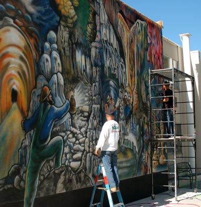
In 2016, concurrent with the NSS Convention in Ely, the heritage area's partnership arm helped fund a mural recognizing Absolom Lehman's explorations in the Lehman Caves of Great Basin National Park. Designed by NSS cave artist, Carolina Shrewsbury, the mural is now permanently installed on Highway 50 in downtown Ely.
The National Heritage Area includes Great Basin National Park and portions of Humboldt-Toiyabe and Fishlake National Forests, as well as Fort Deseret, Sevier Lake and the Topaz War Relocation Center.