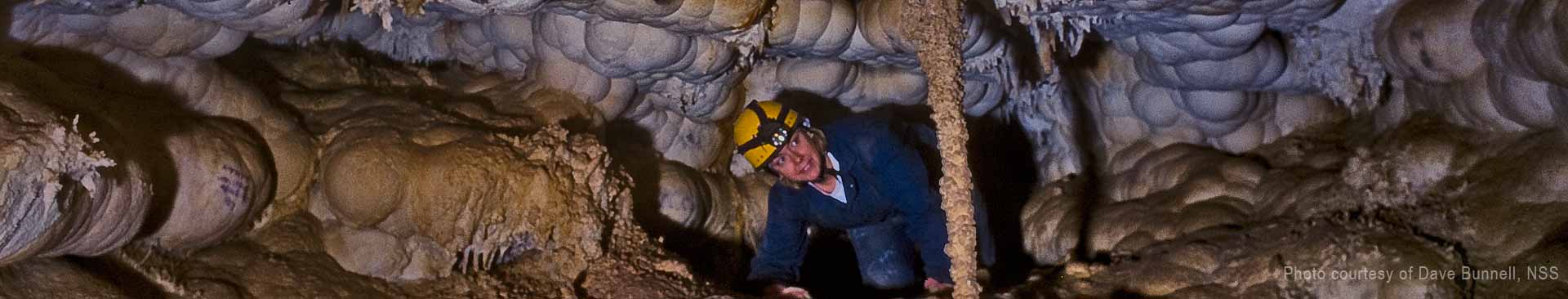
Photo by Dave Bunnell, UnderEarth Graphics
Most of the caves of eastern Nevada have formed in beds of relatively pure to somewhat cherty limestone. During the Paleozoic Era, roughly between 542 and 251 million years ago, most of the sedimentary rocks present in Nevada south of a diagonal line drawn from Lake Tahoe on the California-Nevada border and the extreme northeastern tip of the state were deposited in shallow seas west of the nascent North America continent. Subsequently, continental scale crustal movements carried North America west and bumped into these shallow water rocks, plastering them against the continental borderlands. The oceans came and went as the North American tectonic plate slowly pushed its way westward, burying these rocks, twisting them and squeezing them into limestone, some with thin stringers of chert. Most of this rock torture took place in the following Mesozoic Era that stretched between about 245 and 65 million years ago. Some of these older rocks were pushed deep into the crust where they melted and gradually rose to form large masses or plutons of granitic rock. These plutons are largely responsible for the extensive and varied ore deposits such as the Comstock Lode (the richest single ore deposit ever found) that Nevada is famous for. Concurrently, other slabs of rock to the east were intruded with granitic rock and buckled up to form the Rocky Mountains at what was then the western edge of North America.
At about the end of the Mesozoic at the climax of the Age of Dinosaurs some 65 million years ago, a large slab of the adjacent old Pacific Ocean bottom to the west was over-ridden and supposedly sank into the Earth's crust to be consumed and recycled as granitic rocks as already mentioned. This slab of California rock, however, as was typical of most things Californian, was a non-conformist and instead pushed its way east under the western edge of North America to about where Salt Lake City stands today. The resulting upward bowing of the crust stretched it apart. Formerly quiet slabs of rock were fractured to start forming the Great Basin. Gradually the entire area started to settle down a bit, but because of continued continental unrest, these rocks were faulted up with their western edges higher than the foundering eastern edges to form the north-southtrending mountain ranges of the Great Basin that geographers have likened to an army of caterpillars slowly inching their way north from Mexico. To the northwest, long offshore volcanic island chains belched forth large amounts of lava, volcanic ash, and allied sediments that even had a few offshore coral reefs that were to become limestone. By and large, however, most of the northwestern part of Nevada is cave-less. What a pity.
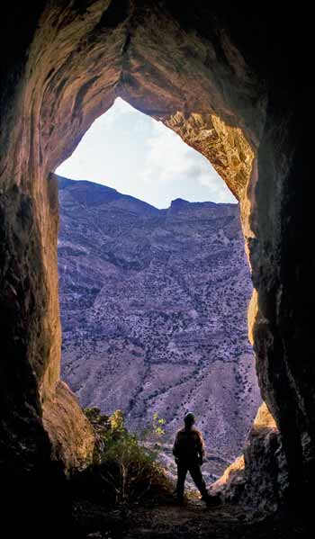
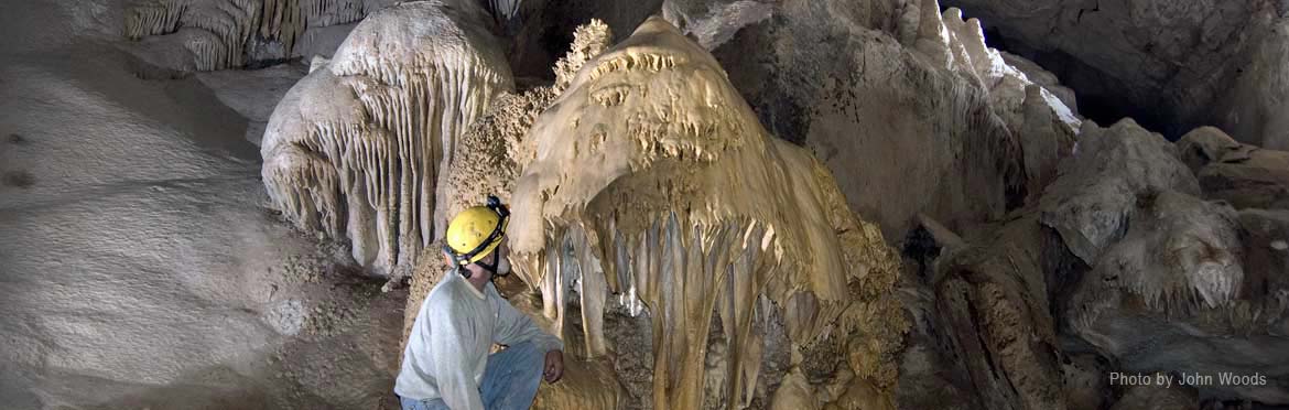
Lehman Cave photo by Gretchen Baker, NPS
About 20 million years ago the Sierra Nevada to the immediate west rose to nearly two miles in height. This effectively shut off the moisture-laden winds from the Pacific Ocean and started the desertification of the bucolic central Nevada terrain of what was to become the Great Basin. The Sierra Nevada, itself a microplate some 400 miles long and nearly 140 miles wide, was then worn down to modestly high hills until a renewed uplift, perhaps 2 to 3 million years ago, again pushed these rocks up to about three miles in elevation.
Once western North America stabilized just a bit more and Nevada took a breather, descending films of ground water sank into the thin soils. Soil bacteria produce about 100 times the amount of carbon dioxide than is present in the air we breathe and thus the downward seeping ground water became carbonic acid, a chemical soup in which limestone is very soluble. The weak acid slowly dissolved out the limestone along nearly-vertical joints and gently inclined bedding planes. At first isolated chambers and pockets were formed because of the reduced amount of ground water available. These embryonic caves formed close to what was then the "water table" - really a misnomer since there is no classic water table in karst areas, only isolated reservoirs, standpipes, and tubes so to speak. In any case the caves being formed were largely isolated and not integrated into networks of passages. The pockets and isolated chambers then sat idle, being filled with ground water fully saturated with dissolved calcite and with nowhere to go.
Gradually the surface was eroded down, streams cut their canyons deeper, and what ground water there was slowly drained away to the lower, gravelfilled inter-montane basins. This allowed fresh acid ground water to percolate in, dissolving larger rooms and more passages. In some cases, geothermal heat warmed the ground water and aided in dissolving the caves, but in only a few instances. The major rooms in many of Nevada's caves most probably started as large, isolated chambers. Gradually these coalesced into irregularly shaped rooms with fairly large vertical extent. These rooms often roughly parallel the range fronts because the cave-guiding faults and joints approximately parallel the range fronts themselves. Cave Valley Cave, for instance, roughly follows the trend of its enclosing limestone hill, itself roughly parallel to the faults bounding Cave Valley and the bordering South Egan and Schell Creek Ranges. The same may be said for the lofty passages in Whipple Cave to the south and the group of major caves in the Smith Creek area.
In other locations, the surface drainage has played a major role in guiding the development of caves. In Baker Creek at Lehman Cave, for instance, the cave passages are a direct result of continued solution of the limestone adjacent to and under the bed of Baker Creek.
Other caves apparently reflect their development as large "pores" in the massive limestone of their respective enclosing mountain ranges. Rose Guano Cave, Whipple Cave, and Mining Canyon Cave are examples of this seemingly random development (but we add that detailed studies of many of these caves have not been made and there may be other factors influencing their development).
Still other Nevada caves are the result of solution of limestone along a relatively narrow pathway. Karst springs such as Ragged Cave in Eastern Nevada and Deer Spring Cave in the Charleston Range in the far western edge of the state owe their development to a network of cracks and fissures that funnel ground water to a single outlet. Model Cave near Lehman Cave appears to have also been a fully water-filled pressure tube cave that only recently has been faulted open. Abundant scallops, oval cross section passages, and other features show its initial development fully under the water table followed by faulting open and draining to form a seasonally flooded lengthy cave partly still partly filled with its much older sediment fill.
Beware Cave at the Nevada-Utah border is another special case cave. It has formed inside a modestly large deposit of calcite travertine. The thermal water has ascended along a fault, bringing dissolved calcite with it (this fault most likely is the same which played a major role in the location of Gandy Peak proper that holds both Crystal Ball Cave and several other smaller caves). This pinnacled block of limestone may either be an up-faulted outlier of the Snake Range or possibly a large landslide block of enormous proportion that has slid east from the main range. In any case the warm, calcite-saturated waters have formed a lovely little cave as an outlet for a major, warm water karst spring.
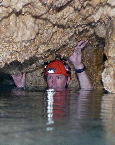
Spring photo by James Rice
Thus many of Nevada's caves are relatively newly formed. We do not have any good dates for most of this solution, but we do know that at nearby Lehman Cave, its passages are essentially horizontal and not affected by the roughly 2 million years ago uplift episode of the enclosing Snake Range. This was the time of the last major episode of faulting and drastic uplift to the eastern Great Basin ranges in the immediate cave area, although slow uplift continues today. Since many of the eastern Nevada caves also lack any systematic, east-west tilting with side passage being either above and below the main cave's elevation, it may be assumed that they, too, are less than 2 million years old.
Uranium-thorium radiometric dates from a pair of stalagmites from Lehman Cave obtained by geologists in 2015 show a spurt of growth between 16,400 and 3,800 years ago with a hiatus between 12,700 and 8,200 years ago. These growth spurts may reflect the colder and thus wetter environments of the Older Dryas and Younger Dryas time intervals that centered about 14,000 and ~12,900-11,700 years ago. The Lehman stalagmite record also shows a drying trend after about 8,200 years ago. These dates agree well with those of other studies showing the general drying of the Great Basin during the past at least 2 million years. So we may conclude that, as in the case of Lehman Cave, most of the decoration of many of eastern Nevada's caves started forming in the late Pleistocene Epoch and continued forming in the Holocene Epoch; i.e., between approximately 130,000 years ago and the present. This dates the actual formation of these caves to well before about 130,000 years ago since the cave needs to be present before being decorated.
Several cavers/graduate geology students/members of the now inactive Stanford Grotto spent the entire summer of 1952 studying the caves of the southern Sierra Nevada and Nevada. They made excellent observations on many of the Nevada caves. Lacking the knowledge we now posses because of radiometric dating and other sophisticated age dating methods, some of their speculations are somewhat wide of the mark. However, being keen observers, they, too, deduced that some of the largest caves in eastern Nevada may be as old as Pliocene and were subsequently modified in the wetter intervals of Pleistocene and Holocene Epochs, i.e., between about 5 and 1 million years ago. Thus until someone comes forth with a large bag of gold coin to pursue this facet of Nevada's natural history, we will have to speculate as best as we can.


The Karst Waters Institute is a 501(c)3 nonprofit institution whose mission is to improve the fundamental understanding of karst water systems for professionals and the public.
The institute works to engage professionals in small conferences and workshops to advance karst science; increase recognition and publication of karst science; foster development of karst professionals; and to communicate and disseminate information to the public.
![]() Scattered showers and thunderstorms between 11am and noon, then showers and thunderstorms between noon and 4pm, then scattered showers and thunderstorms. Mostly cloudy. High near 91, with temperatures falling to around 82 in the afternoon. Northwest wind 0 to 5 mph. Chance of precipitation is 90%. New rainfall amounts between a quarter and half of an inch possible.
Scattered showers and thunderstorms between 11am and noon, then showers and thunderstorms between noon and 4pm, then scattered showers and thunderstorms. Mostly cloudy. High near 91, with temperatures falling to around 82 in the afternoon. Northwest wind 0 to 5 mph. Chance of precipitation is 90%. New rainfall amounts between a quarter and half of an inch possible.
![]() Scattered showers and thunderstorms before 9pm, then scattered showers and thunderstorms between 9pm and 10pm, then isolated showers and thunderstorms between 10pm and 11pm. Mostly cloudy, with a low around 54. West northwest wind 5 to 10 mph. Chance of precipitation is 30%. New rainfall amounts less than a tenth of an inch possible.
Scattered showers and thunderstorms before 9pm, then scattered showers and thunderstorms between 9pm and 10pm, then isolated showers and thunderstorms between 10pm and 11pm. Mostly cloudy, with a low around 54. West northwest wind 5 to 10 mph. Chance of precipitation is 30%. New rainfall amounts less than a tenth of an inch possible.
![]() Scattered showers and thunderstorms between 11am and noon, then a chance of showers and thunderstorms between noon and 5pm, then scattered showers and thunderstorms. Partly sunny, with a high near 87. West wind 0 to 5 mph. Chance of precipitation is 70%. New rainfall amounts less than a tenth of an inch possible.
Scattered showers and thunderstorms between 11am and noon, then a chance of showers and thunderstorms between noon and 5pm, then scattered showers and thunderstorms. Partly sunny, with a high near 87. West wind 0 to 5 mph. Chance of precipitation is 70%. New rainfall amounts less than a tenth of an inch possible.

Notch Peak, located in West Millard County, Utah, and visible from Great Basin National Park, towers above the desert valleys at 9,725 ft. elevation. This 3,000 ft sheer cliff is one of the tallest limestone cliffs in America.

WCC Ball Cap
Wearing a ball cap? Oh, that's a whole vibe. It's like saying, "I'm strong, but I'm not here for your speleo-approval." It's the kind of quiet power that doesn't scream for attention, but when it walks into the room, everyone knows it's the real deal. No need to flaunt or flex when you've got that kind of effortless strength, right?
Yet, while being grounded and focused on what truly matters, you can still shine at your next grotto meeting by declaring your subtle support of the Western Cave Conservancy!

The Hydrographic Great Basin is a 200,000 square mile area of the American West that extends from the Sierra Nevada Range in California to the Wasatch Range in Utah, and from southern Oregon to southern Nevada. The entire basin contains what's called an endorheic watershed. All precipitation in this region evaporates, sinks underground, or flows into lakes. No water reaches the ocean.