Geology of the Snake Creek and Schell Creek Ranges and Development of Their Caves
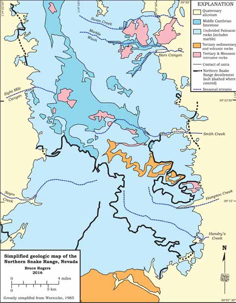
Article & PlatesThis study area is located in the central Great Basin in eastern White Pine County, Nevada. This area is centered on the Snake Creek Range, a roughly 150-kilometer long, north-trending range. To the immediate west is the Schell Creek Range, a roughly parallel range extending 70 kilometers further north. Conner Pass separates the southern third of the Schell Creek Range from the northern two-thirds while Sacramento Pass splits the Snake Creek Range into two approximately equal segments.
The range's highest elevations are 11,890 feet (3,625 m) at Schell Peak in the middle Schell Creek Range. Just to the east, 12,050-foot-high (3,674 m) Mt. Moriah in the northern Snake Creek Range compliments the summit of Wheeler Peak at 13,063 feet (3,982 m) in the south-central Snake Creek Range. The intervening valley bottoms average about 5,000 feet (1,525 m) in elevation. Deeply incised canyons cut these ranges with the longest canyons on the eastern slopes. The vegetation is typical Great Basin cold desert shad scale at the lower elevations ranging up to small limber and bristlecone pine groves at the range summit areas.
The Snake Creek Range in particular is cited as an outstanding example of a Cenozoic metamorphic core complex. That is, a plate of complexly faulted but unaltered rocks have been faulted over another section of equivalent, but metamorphosed, rocks. Despite nearly 60 years of study, the exact style of tectonics and timing are still being debated. That said, the basic tectonics have essentially unaltered Paleozoic (570- to 245-million year old) and Tertiary (65- to 2-million-year old) rocks have been thrust over a metamorphosed, stretched section of Late Proterozoic Era (900- to 570-million-year old) to Cambrian and Ordovician Period (approximately 570- to 470-million-year old) rocks. The trusting has taken place during the Cenozoic Era with several episodes of faulting centered in middle Eocene Epoch (about 45 million years ago), again in the late Oligocene Epoch (about 28 million years ago), and finally in the early to middle Miocene (17 million years ago).
The rocks underlying the northern Snake Creek Range are largely quartzite (metamorphosed sandstone) and argillite (a highly metamorphosed shale), along with some Cretaceous Period volcanic rocks. The southern reach of the Snake Creek and southern Schell Creek Ranges are mostly Paleozoic Era limestone, shale, and sandstone that are partly metamorphosed into marble, calcareous schist, and quartzite, respectively, plus some small bodies of granitic rocks.
The majority of the rocks in this area formed during the Cambrian Period, a time when western North America was located near the equator as part of the ancient Laurentia continent. Thick layers of limestone, shale, and sandstone accumulated along the stable continental margin in a setting similar to the present Caribbean Sea. There, shallow warm sea waters encouraged the generation of vast banks of lime mud stretching out from coral-bound coastlines. In areas with granitic rocks, quartz grains accumulated to form sand bars along the coast. Further offshore, deeper basins slowly filled with fine grained, siliceous mud. During the next one hundred million years or so, these sediments were compressed and became limestone, sandstone and shale, respectively.
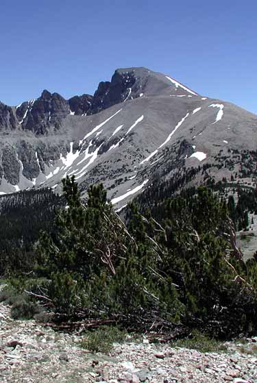
The Snake Range is a mountain range in White Pine County, Nevada. The south-central portion of the range is included within Great Basin National Park, with most of the remainder included within the Humboldt-Toiyabe National Forest. The range reaches a maximum elevation of 13,065 feet at the summit of Wheeler Peak. Photo by Dave Bunnell, UnderEarth Graphics
Read MoreThese rock units have been twisted, compressed, and heated during numerous episodes of mountain building or orogenies. These included the Antler Orogeny during the Devonian Period (the Age of Fishes) between 370 and 340 million years ago (Ma), the Sonoma Orogeny during the Permian Period (Age of Reptiles) between 270 and 240 Ma, and the Sevier Orogeny during the Cretaceous Period (Age of Dinosaurs) between 80 and 70 Ma. The Sevier Orogeny thrusted thick layers of rock on top of one another that locally doubled the thickness of the Earth's crust.
During the Cretaceous Period, magma (molten rock) formed within the Earth's interior and, being less dense than the surrounding rocks, slowly intruded its way up into the overlying rock layers. This magma cooled, forming the bodies of granite found throughout the area. The combination of pressure and heating from both the thrust faulting and baking by the intruding granitic rocks has caused the metamorphism that locally has altered some of the sandstone into quartzite, shale into slate, and limestone into marble.
The modern basin and range topography is relatively new, forming during the past 30 million years, during which time the underlying crust of the Great Basin has been subjected to extensive stretching and thinning. The result of this stretching caused the crust to break up into blocks. Most of these blocks tilted downward on their eastern sides, resulting in an east west "sawtooth" profile. The western, faulted faces of the blocks form the high mountain ranges, while the eastern parts of the blocks underlie the closed valleys present today.
After the initial uplift (that is continuing today), the mountains in the Snake and Schell Creek Ranges were shaped by a variety of erosional and depositional processes. The most influential of these was Pleistocene Epoch glaciations that occurred during several distinct "Ice Ages" over the past 1.8 million years. The modern landscape of these ranges provides evidence for extensive glaciation from 60,000 to 40,000 years ago and again from 25,000 to 14,000 years ago.
As the glaciers grew in response to cooler summers and snowier winters, they moved down slope from the high peaks. The ice eroded canyon walls and replacing V-shaped valleys that are typical of stream erosion with U-shaped valleys characteristic of glaciated areas. These glaciers carved out several cirques (horseshoe-shaped erosional features with sharply crested surrounding ridges on their three uphill sides). When the ice retreated, it left behind alpine lakes as well as linear debris ridges called moraines that indicate where the edge of the glacier was. Examples of these alpine features are best preserved in the high peaks areas of adjacent Great Basin National Park. With the higher rainfall caves undoubtedly formed throughout the ranges and some of the higher elevation caves may date to this time, but only further study will verify or refute this speculation.
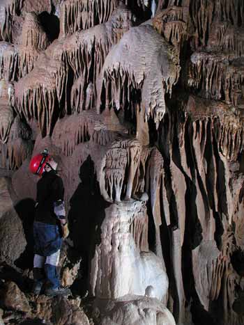
Photo by Dave Bunnell, UnderEarth Graphics
The development of caves in the Snake Creek and Schell Creek Ranges began well after the consolidation and faulting of the limestone and marble bedrock. During the tectonic jumbling and faulting of the rocks, a multitude of cracks and smaller faults developed. These would provide miniscule avenues for water to begin their patient work of excavating the caves. Rainwater, as it falls, picks up a bit of carbon dioxide from the air. Once the water enters the thin soils, it picks up much more carbon dioxide present that is a byproduct of the soil microorganisms. As this carbonic acid-charged water slowly seeps down along the joints and faults, it dissolves tiny amounts of calcite, the mineral that forms limestone and marble.
We are still not exactly sure when most of this solution took place, but we have some evidence it was fairly recently. During the ensuing 1.8 million years of the Pleistocene, the climate was cooler and wetter and thus water was more abundant throughout the southwestern United States. This caused more water to seep into the ground and eventually into the fractured bedrock. Lehman Caves have dissolved in the marble along joints and faults and have extensive areas of horizontal ceilings in their passages and rooms. Knowing that most cave solution takes place within a few meters of the water table, we can assume that these rooms and passageways have not been tilted since their formation. Poorly cemented gravels dated to the Pleistocene or Late Tertiary Period are found throughout the Snake Creek Range and are tilted down about 20 degrees. Since none of the passages in Lehman Caves are tilted we can assume those passages have not been tilted during the last one, two, or possibly five million years.
As surface streams cut their channels deeper into the mountains, the ground water elevation also dropped. Over time, the passages and galleries of the caves were slowly drained of the now calcite-saturated water. As the surface also slowly was eroded downward, entrances to the caves formed. The saturated water, now able to equilibrate with the outside air, discharged its dissolved carbonic acid much like an uncapped soda. Unable to hold the calcite in solution, the mineral was deposited in the now vacant caves. In some caves, surface streams found the cave entrances and utilized the cave passages as channels and deposited thick layers of sediment. Often these hold fossils of extinct animals that assist in dating this stage of the cave's development. Later yet, other animals wandered or fell into the caves and died, adding their remains to the slowly growing pile of sediment. In several caves in the Snake Range, large numbers of fossil bones from Ice Age animals have allowed paleontologists to reconstruct the climate, and thus vegetation and animals that grazed upon it, thousands of years ago.
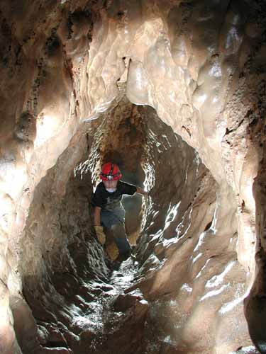
Photo by Dave Bunnell, UnderEarth Graphics
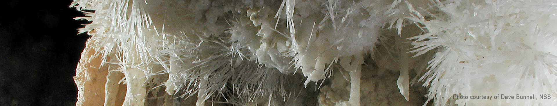
As the seeping and flowing water made it way into the cave chambers, it deposited many different forms. Stalactites began as tiny rings of calcite deposits around hanging drips of water on the ceiling; the resulting hollow tubes are called soda straw stalactites. Later, water flowing along the outside of these soda straws slowly built the carrot-shaped stalactites seen today. As the flowing water dropped its calcite load, curtain-shaped sheets of calcite termed draperies formed along sloping walls. In a last effort, the dripping water released its mineral load upon impact with the cave floor to form pillar-like stalagmites.
Seeping water, ruffled by irregularities on the cave walls and floor, also dropped their calcite to form flowstone, a deposit resembling frozen, cascading water, but made of hard calcite. Slower seeping water released its calcite to form cave coralloids in an amazingly diverse selection of forms resembling ocean corals.
Sometimes ground water built up behind a sheet of flowstone and, upon finding a tiny hole, seeped out to leave its calcite as cone-shaped crystals. Over time, the ground water, still under pressure and slowly seeping out along a tiny central channel within the decoration, formed a pile of calcite crystals that twist and turn. These are called helictites and resemble a stack of inverted ice cream cones which don't exactly fit atop each other, thus allowing the helictite to whimsically twist and turn. The same basic process, but occurring along a linear fracture, forms disk-shaped deposits shaped like dinner plates or artists' palettes. These shields are uncommon, but many caves in the Snake Creek Range, especially in Lehman Caves, are notable for their size and delicacy.
As with most living things, caves have a life cycle. The decorations, called speleothems, often fill passages and rooms back up with calcite. More often, however, either surface erosion unroofs the caves or streams pack the cave passage solidly with sediments. Collapse of large chambers may leave natural bridges like Lexington Arch that can only hint at the impressive size of the former caves themselves.

The Great Basin National Heritage Area is the epitome of remote destinations with the Great Basin National Park, hundreds of miles of ATV trails, and numerous natural attractions. Explore the wide open spaces, travel uncrowded trails, and experience some of the darkest night skies in the country.
![]() Scattered showers and thunderstorms between 11am and noon, then showers and thunderstorms between noon and 4pm, then scattered showers and thunderstorms. Mostly cloudy. High near 91, with temperatures falling to around 82 in the afternoon. Northwest wind 0 to 5 mph. Chance of precipitation is 90%. New rainfall amounts between a quarter and half of an inch possible.
Scattered showers and thunderstorms between 11am and noon, then showers and thunderstorms between noon and 4pm, then scattered showers and thunderstorms. Mostly cloudy. High near 91, with temperatures falling to around 82 in the afternoon. Northwest wind 0 to 5 mph. Chance of precipitation is 90%. New rainfall amounts between a quarter and half of an inch possible.
![]() Scattered showers and thunderstorms before 9pm, then scattered showers and thunderstorms between 9pm and 10pm, then isolated showers and thunderstorms between 10pm and 11pm. Mostly cloudy, with a low around 54. West northwest wind 5 to 10 mph. Chance of precipitation is 30%. New rainfall amounts less than a tenth of an inch possible.
Scattered showers and thunderstorms before 9pm, then scattered showers and thunderstorms between 9pm and 10pm, then isolated showers and thunderstorms between 10pm and 11pm. Mostly cloudy, with a low around 54. West northwest wind 5 to 10 mph. Chance of precipitation is 30%. New rainfall amounts less than a tenth of an inch possible.
![]() Scattered showers and thunderstorms between 11am and noon, then a chance of showers and thunderstorms between noon and 5pm, then scattered showers and thunderstorms. Partly sunny, with a high near 87. West wind 0 to 5 mph. Chance of precipitation is 70%. New rainfall amounts less than a tenth of an inch possible.
Scattered showers and thunderstorms between 11am and noon, then a chance of showers and thunderstorms between noon and 5pm, then scattered showers and thunderstorms. Partly sunny, with a high near 87. West wind 0 to 5 mph. Chance of precipitation is 70%. New rainfall amounts less than a tenth of an inch possible.
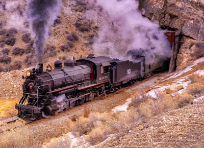
Track for the Nevada Northern Railway was laid over a century ago, connecting one of the largest copper mines in North America to the Transcontinental routes to the north. Today, several of the original steam locomotives that were used over a century ago are still in operation. The Nevada Northern Railway is the best-preserved example of a standard-gauge short-line left in North America.
The 2025 NCKMS conference will include a geology-themed trip aboard this historic railway.
Campfire Coffee Mug
Stay up all night with our personalized ceramic coffee mug.
This 13oz mug is perfect for school, campfire socials, marathon thesis proofreading, and all-night grant-writing sessions.