
Audio Tour: Sacramento Pass, Baker & Great Basin National Park
The Baker Archaeological Site, also known as Baker Village, contains the remains of a Fremont Indian village occupied from approximately 1220 to 1295 CE. The Fremont lived in this well planned community of several small pit houses and granaries, surrounding a main big house, and practiced a form of agriculture.
The site was excavated by Brigham Young University's Office of Public Archaeology, in cooperation with the BLM, from 1991 to 1994. Recovered artifacts are currently stored at BYU's Museum of People and Cultures in Provo, Utah.
After the excavations, the site was backfilled (reburied with the dirt that was removed during excavation), a necessary step in protecting the cultural features that remain. As a result, the foundations of the village can no longer be seen on the surface. The walls visible today are modern walls, built in 2002. Artifacts found on the ground may be observed, but not removed, from the site.
The site is currently administerd by the Bureau of Land Management. Brochures and an information kiosk are located at the parking area. A restroom, picnic tables, and a sun shelter are available for day use. No water is available.
The Baker Archaeological Site is located on a cut-off road that runs between NV Hwy 487 at Baker, Nevada, and US Hwy 6/50. The cutoff is one-half mile north of the Great Basin Visitor Center.

Fremont Pilling Figurines, unfired clay Fremont figurines, on display in the College of Eastern Utah Prehistoric Museum. Image by Brian Lee/CC BY-SA 3.0 (Wikimedia).
Fremont and Ancestral Puebloan people began to incorporate farming into their hunter-gatherer lifestyles approximately 2,000 years ago. Baker Archaeological Site is the most western site attributed to the Fremont culture.
Anthropologists suggest that the Fremont were hunter-gatherers who supplemented their diet by farming corn, beans, and squash along waterways and floodplains. Edible native plants included pinyon nuts, rice grass, and a variety of berries, nuts, bulbs, and tubers. Corn was ground into meal on a stone surface (metate) using a hand-held grinding stone (mano). Deer, bighorn sheep, rabbits, birds, fish, and rodents were hunted using snares, nets, fishhooks, the atlatl (spear-throwing stick) and the bow and arrow.
Several artifacts are distinctive to the Fremont. A unique style of basketry, called one-rod-and-bundle, incorporated willow, yucca, milkweed and other native fibers. Pottery, mostly graywares, had smooth, polished surfaces or corrugated designs pinched into the clay. The Fremont made moccasins from the lower-leg hide of large animals, such as deer, bighorn sheep, or bison. Dew claws were left on the soles, possibly providing extra traction on slippery surfaces.
Elevation: 5,278 ft
State: Nevada
District: White Pine County
Coordinates (WGS84): 39.03737; -114.12246
Nearest town: Baker, NV
Distance from the convention center: 62 miles

The Fremont culture or Fremont people is a pre-Columbian archaeological culture which received its name from the Fremont River in the U.S. state of Utah, where the culture's sites were discovered by local indigenous peoples like the Navajo and Ute.

The National Cave and Karst Research Institute (NCKRI) is a nexus of research, stewardship, outreach and information for caves and karst while fostering interdisciplinary collaborations, created by the US Congress in 1998 in partnership with the National Park Service, State of New Mexico, and the City of Carlsbad.
NCKRI is located in Carlsbad, NM, and is a research center of the New Mexico Institute of Mining and Technology.
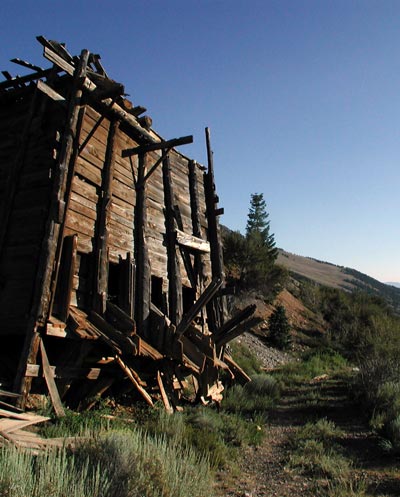
White Pine County, home to Great Basin National Park, lays claim to some of the most famous ghost towns in Nevada: Hamilton (the former county seat), Osceola (where the largest gold nugget in the state was found) and Cherry Creek.
![]() Patchy smoke after 2am. Mostly clear, with a low around 56. South southeast wind around 10 mph.
Patchy smoke after 2am. Mostly clear, with a low around 56. South southeast wind around 10 mph.
![]() Patchy smoke before 10am. Sunny, with a high near 95. South southwest wind 10 to 15 mph.
Patchy smoke before 10am. Sunny, with a high near 95. South southwest wind 10 to 15 mph.
![]() Patchy smoke between 8pm and 1am. Mostly clear, with a low around 57. South southeast wind 10 to 15 mph.
Patchy smoke between 8pm and 1am. Mostly clear, with a low around 57. South southeast wind 10 to 15 mph.

2025 NCKMS T-Shirts
Of course we'll have t-shirts! What would a caver event be without them?
It might look like this thing that an AI system suggested, but we're having real humans dress it up a bit. Might look completely different by the time our humans are done with it.
Our theme at NCKMS this year is "Hidden Waters - Hidden Life". So, we have a concept at least!