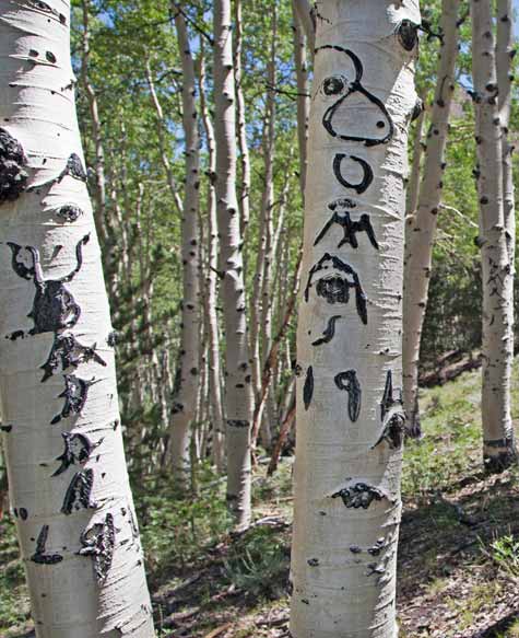
Historic arborglyphs on Success Loop Road. Image compliments of Nevada Comssission on Tourism.
Please keep in mind that many of these destinations are off the beaten path. In Nevada, you should treat off-road explorations much like you would a cave trip. Open mine shafts and old buildings present many dangerous hazards to an unwary visitor. Stay alert and aware. Always let someone know where you are going and when you plan to return. Carry sufficient gas, water, food and a spare tire. Services are few and far between and mobile devices are typically useless. As in caving: take nothing but pictures, kill nothing but time.
Additional self-guided trips around the Great Basin will be added in the coming months. Please check back for updates.
Details
Distance: 110 miles round-trip from Ely, Nevada
Coordinates (WGS84): 39.2768, -115.5144
Elevation: 7,500 ft
District: White Pine County Mining District
Nevada's ghost towns are settlements that grew quickly in response to discoveries of gold, silver, or other minerals. In many cases, these towns became county seats, only to lose that designation once the town's resources became exhausted and its population dwindled.
They were bustling centers of activity, with churches, saloons, and general stores, but once the population moved on to the next big strike, the abandoned towns fell into disrepair.
Ghost towns are a great way to step back in time and see what life was like for the folks who built Nevada and mined the precious metals, ores, and minerals that would come to define the West.
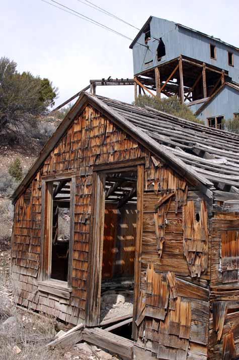
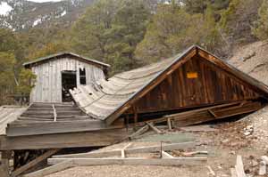
Situated about an hour west of Ely off the Loneliest Road in America, Belmont Mill is a remnant of the area's prestigious mining booms that enticed westward pioneers back to the east to grab onto their piece of the American Dream. Image by Matt Bowers, Third Media.
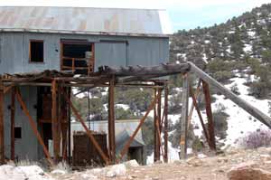
Download Road LogThe Belmont Mine and Mill were worked early in the 1900s by the Tonopah Belmont Development Mining Company. This fascinating camp gave the White Pine Mining District it's last breath of life. Silver-lead ore from this mine was processed at the mill and then shipped off to Eureka, Nevada.
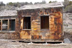
At one time, the White Pine Mining District was a thriving community of 10,000 people at 8,000 feet above sea level scattered across the mountain range. Numerous buildings still exist in various stages of decay. Some of their purposes are obvious, some will require your imagination. Now completely abandoned, this is one of the best preserved sites from the early 20th century mining rush.
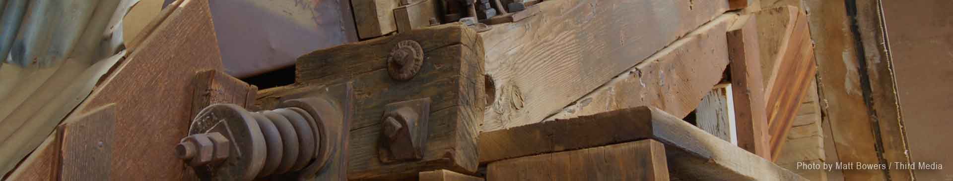
Cables from the Belmont Mill's ore haul system still extend 3 miles up the mountain to the mine. If you walk up behind the mill, you can see the tension system used to keep the lines tight during hot summers and brutally cold winters. The huge tension box of rocks is just hanging by a (very) old chain. We really don't suggest climbing on or going inside the building. The US Forest Service recently shored up the mill, but its integrity is still somewhat questionable.
If you have a 4wd vehicle with decent clearance, you can drive up to the mine by backtracking to the first intersection and turning right on the road that leads up the mountain. At last report, the road was in semidecent condition, but there are some areas of steep exposure. If you're afraid of heights, this isn't for you.
Please note, this is a federally protected historic site. Take nothing but pictures. Kill nothing but time.
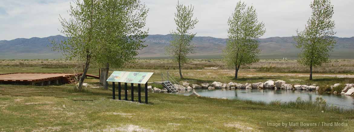
Big Warm Spring is located on the Duckwater Shoshone Reservation about 70 miles west of Ely. In 2007, the tribe partnered with the US Fish & Wildlife service to reintroduce the Railroad Valley springfish to this unique ecosystem. Image by Matt Bowers, Third Media.
Learn More
The Great Basin National Heritage Area is the epitome of remote destinations with the Great Basin National Park, hundreds of miles of ATV trails, and numerous natural attractions. Explore the wide open spaces, travel uncrowded trails, and experience some of the darkest night skies in the country.
Established by congress in 2006, the Great Basin National Heritage Area is a federally designated National Heritage Area in White Pine County, Nevada and Millard County, Utah. The area was defined to recognize and promote the scenic and cultural resources associated with this central portion of the Great Basin.
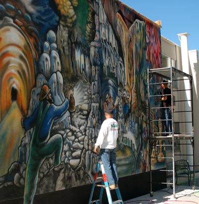
In 2016, concurrent with the NSS Convention in Ely, the heritage area's partnership arm helped fund a mural recognizing Absolom Lehman's explorations in the Lehman Caves of Great Basin National Park. Designed by NSS cave artist, Carolina Shrewsbury, the mural is now permanently installed on Highway 50 in downtown Ely.
The National Heritage Area includes Great Basin National Park and portions of Humboldt-Toiyabe and Fishlake National Forests, as well as Fort Deseret, Sevier Lake and the Topaz War Relocation Center.
![]() Mostly cloudy, with a low around 59. South wind around 5 mph.
Mostly cloudy, with a low around 59. South wind around 5 mph.
![]() Scattered showers and thunderstorms after noon. Partly sunny, with a high near 92. South southwest wind 0 to 5 mph. Chance of precipitation is 50%. New rainfall amounts less than a tenth of an inch possible.
Scattered showers and thunderstorms after noon. Partly sunny, with a high near 92. South southwest wind 0 to 5 mph. Chance of precipitation is 50%. New rainfall amounts less than a tenth of an inch possible.
![]() Scattered showers and thunderstorms before 11pm. Mostly cloudy, with a low around 56. West northwest wind 0 to 5 mph. Chance of precipitation is 50%. New rainfall amounts less than a tenth of an inch possible.
Scattered showers and thunderstorms before 11pm. Mostly cloudy, with a low around 56. West northwest wind 0 to 5 mph. Chance of precipitation is 50%. New rainfall amounts less than a tenth of an inch possible.

h2go Essen Vacuum Food Container
It's a double-wall, stainless steel, 17 oz capacity thermos from h2go®. This thing is more rugged than your cave pack! We've been trying to beat up the manufacturer's sample they sent, but it keeps winning. Hot things stayed hot, cold things stayed cold.
And ours will have the cool NCKMS logo printed on it.